This will be our first flight in five years, and we are eagerly awaiting its arrival. The primary is a brand new design, based on the Arduino archetecture. It includes an ATMega328 processor, a custom AX.25 modulator, and an integrated Inventek GPS engine. The Backup transmitter will be using our proven microcontroller design/MX614 modem. GPS signal is provided by a Garmin GPS-35LVC.
Camera equipment will be a Canon Powershot A570IS camera set on automatic using the CHDK firmware.
| Flight Parameters | |
|---|---|
| Launch Date/Time | Saturday, 1 May 2010 at 8:30am |
| Alternative Date | N/a |
| Launch Site | Wells Aircraft at the Hutchinson Airport (38° 03.8', 97° 51.9'W) in Hutchinson, KS |
| Primary Transmitter / Antenna | ArduinoTrack controller with Radio Shack HT into a vertically polarized dipole antenna. Signing W0ZC-11. |
| Backup Transmitter / Antenna | Custom PT controller with VX-1R into vertically polarized dipole. Signing AJ0NR-11. |
| Balloon / Gas / Positive Lift |
Kaymont 1000gram / 180 cu feet of Helium / 5lbs |
| Estimated Burst Altitude | 90,000' MSL |
| Estimated Ascent Rate | 1250' per minute |
| Estimated Descent Rate | Approx. 1100' per minute at touchdown |
| Capsule(s) weight | 2lbs 7oz + 1lbs 4oz. Total Flight Weight 3lbs 15oz |
| Chase Frequencies | 446.00MHz |
| Balloon Finder Telemetry Mode | PT Mode 2 |
Flight Predictions
| Flight Predictions | |||||
|---|---|---|---|---|---|
| Date Created (Central Time) | Dist From Launch | Bearing From Launch | Relative Position | Map | Winds |
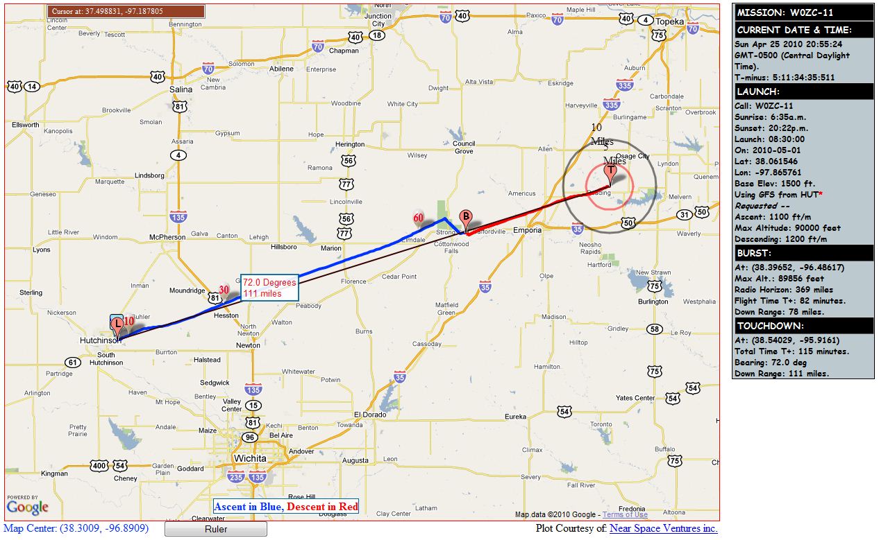
| 4/25/2010 9:00pm | 111 miles | 72° E-NE | 16mi NE of Emporia | Map | Winds |
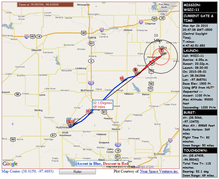
| 4/26/2010 9:00pm | 69 miles | 52° NE | 5mi E of Herington | Map | Winds |
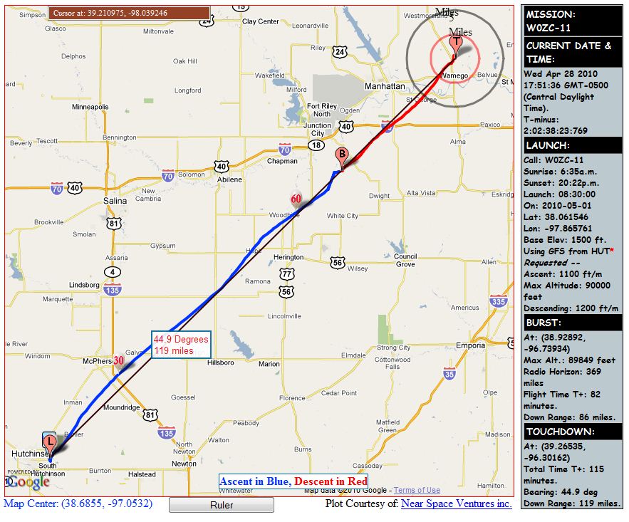
| 4/28/2010 6:00pm | 119 miles | 45° NE | 5mi N of Wamego | Map | Winds |
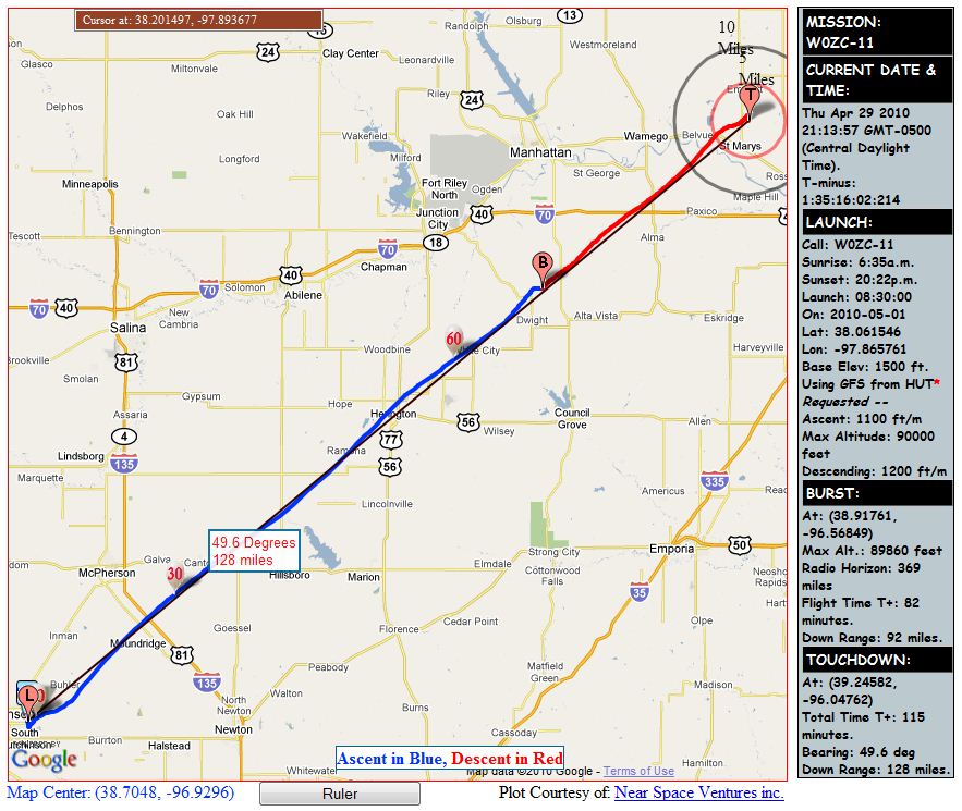
| 4/29/2010 9:00pm | 128 miles | 49° NE | 4mi N of St Marys | Map | Winds |
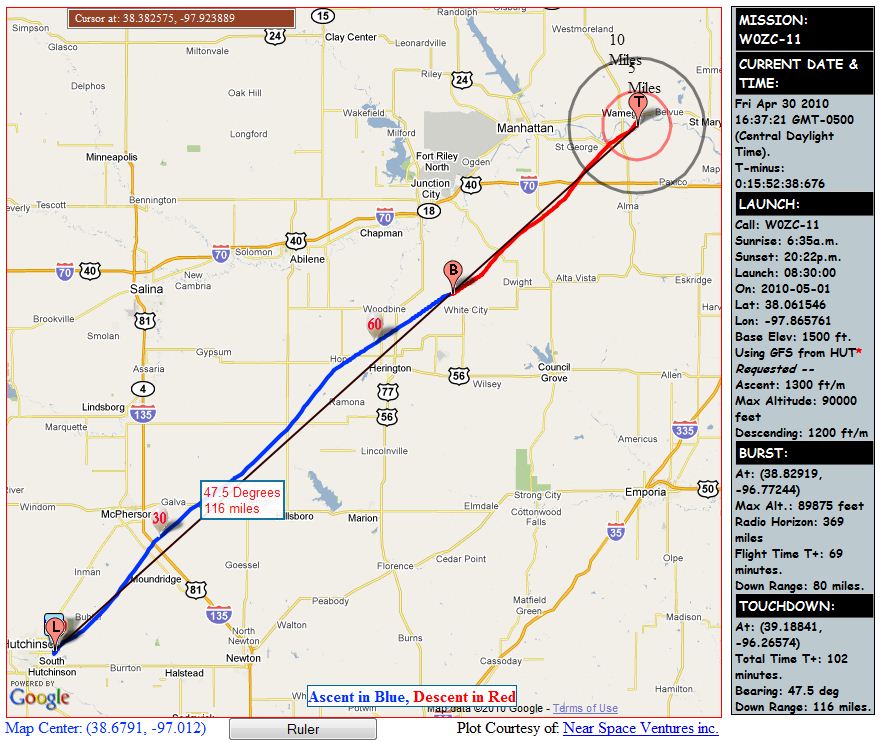
| 4/30/2010 4:30pm | 116 miles | 48° NE | 2mi E-SE of Wamego | Map | Winds |
Flight Results
Overall, I'm considering the flight a success, although we had plenty of surprises.
The most notable was a loss of altitude data coming from the new controller design at 32,000'. My initial suspicions turned out to be accurate, and it was a software issue. A buffer didn't have enough room to handle a 5 digit altitude (10,000 meters), and began to spew random data.
The most disappointing problem that we had (in my opinion) was that the glass protecting the camera frosted over several minutes into the flight, apparently after passing through a rain cloud. Virtually all of the photos were worthless from that point on until it melted a couple of minutes before touchdown.
Touchdown was a little closer to a major highway that I would have liked. I made a last minute call to significantly over-fill the balloon, on the order of about 8 pounds positive lift. In retrospect, I should have put my faith in the flight predictions and stuck to the original 1200'/min ascent, which would have shifted our touch-down ~20 miles north, well away from I-70.
The newest rendition of Balloon Finder worked very well during the tracking in my vehicle. The only error occured when I went to close the program - it was probably a conflict during the shutdown of one of the serial ports. I will try to fix this one and finish cleaning up loose ends before GPSL.
| Flight Statistics | |
|---|---|
| Launch Date/Time | Saturday, 1 May 2010 at 8:35am |
| Launch Site | Wells Aircraft at the Hutchinson Airport (38° 03.8', 97° 51.9'W) in Hutchinson, KS |
| Burst Altitude | 95,820' |
| Average Ascent Rate | 1500' per minute |
| Measured Descent Rate | 1928' per minute (last measured at 9400') |
| Touchdown Site | 39° 1.4740'N, 96° 31.3778'W |
| Touchdown Time | Approx 10:10am |
| Recovery Time | 11:50am |
| Distance Traveled | 98mi |
| Total Flight Time | 1hr 35min |
Lessons Learned
- When it comes to filling the balloon and figuring predictions, stick to the original plan.
- The cloth bag filled with soft foam worked quite well as a payload design. A filleting knife carved the soft foam out very well to make cubby holes for various equipment.