There won't be anything particularly new about this flight, other than an OpenTrack+ controller as a secondary payload.
Updated: I"ve added a third payload package that will include two additional cameras onboard. This will increase the total cameras on board to at least three, and there could be a fouth camera flying still.
| Flight Parameters | |
|---|---|
| Launch Date/Time | Saturday Apr 20, 2013, 8:00am local, 13:00Z |
| Alternative Date | |
| Launch Site | Crossroads Christian Church in Hutchinson, KS. (38.1015, -97.9399) |
| Primary Transmitter / Antenna | ArduinoTrack with Radio Shack HTX-200 HT with vertically polarized dipole - W0ZC-11 - Track Online |
| Backup Transmitter / Antenna | OpenTrack+ controller with Radio Shack HTX-200 HT. W0ZC-12 - Track Online |
| Balloon / Gas | 1200g Kaymont with 220cu' Hydrogen |
| Estimated Burst Altitude | 95,000' MSL |
| Estimated Ascent Rate | 1100 ft/min |
| Estimated Descent Rate | 900 ft/min |
| Capsule(s) weight | 5.7 lbs |
| Chase Frequencies | 446.000MHz |
| Balloon Finder Telemetry Mode | n/a |
Predictions
Friday 19 April, 2013. E Track, landing 25 miles south-southwest of Emporia. It's starting to settle in just south of Highway 50, about 12 miles southwest of the Tallgrass Prairie Preserve.
Thursday 18 April, 2013. E Track, landing 22 miles south-southwest of Emporia. North a bit more today, but not all that different from Wednesday.
Wednesday 17 April, 2013. E Track, landing 22 miles south-southwest of Emporia. Today's prediction is moving further north yet, with a landing about half way between Eureka and Emporia.
Tuesday 16 April, 2013. E-SE Track, landing 10 miles north of Eureka. They're continuing to move to the north, but still well in the clear.
Monday 15 April, 2013. SE Track, landing 15 miles west-southwest of Eureka. The touchdown prediction is continuing to stay well east of Wichita.
Saturday 13 April, 2013. E-SE Track, landing 8 miles north of Eureka. The predictions have shifted north 50 miles or so from the initial predictions I pulled last week, however they're very close to the original path and range.
Flight Results
| Flight Statistics | |
|---|---|
| Launch Date/Time | Saturday Apr 20, 2013, 8:02am local, 13:02Z |
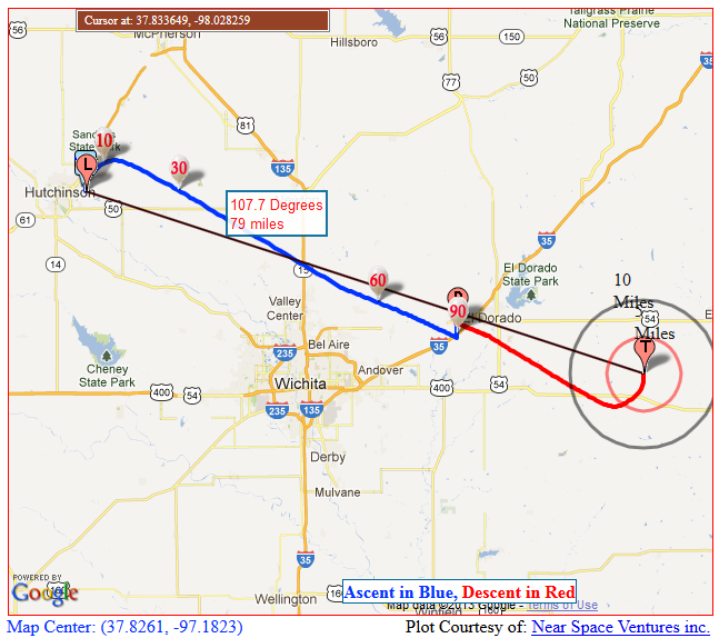
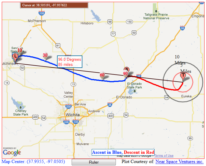
| Launch Site | Crossroads Christian Church in Hutchinson, KS. (38.1015, -97.9399) |
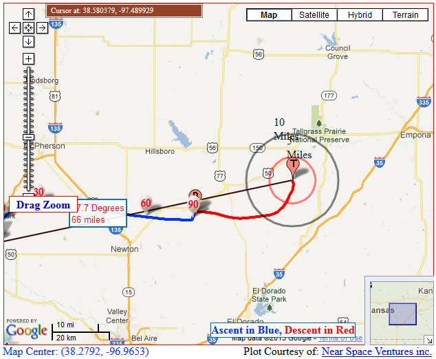
| Burst Altitude | 101,187' MSL |
| Average Ascent Rate | 1102'/min |
| Measured Descent Rate | 1135'/min during final 2 minutes of flight |
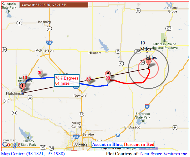
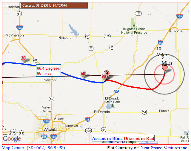
| Touchdown Site | 38 08.96N 96 57.01W |
| Touchdown Time | 10:06am local, 15:06Z |
| Recovery Time | 10:08am local, 15:08Z |
| Distance Traveled | 54 miles |
| Total Flight Time | 2 hours, 4 minutes |
| Downloads | Log File W0ZC-11, Log File W0ZC-12 |
Lessons Learned
We had another un-eventful Hydrogen fill on this flight. The toughest part was obtaining the gas - it took six days longer than expected for the gas to arrive.
The Canon A2300 camera mounted vertically was orientated well, but for some reason failed minutes into the flight. The Canon SX130IS camera mounted in the new camera enclosure failed almost immediately, as there were no in-flight photos from this camera.
The cause of both of the camera failures needs to be investigated. The older Canon A570 performed flawlessly, and was still taking photos after we recovered the payloads.
In addition, the new cameras are not shutting off their LCD displays, and may be causing excessive battery drain, although some have reported on the Internet that disabling the displays by plugging in an external monitoring cable does very little to the overall power consumption of the cameras.
A few last-minute modifications to Balloon Finder were added in and run on Zack's laptop. Those changes performed well and simplified any post-launch restarts or troubleshooting, although the software didn't crash today. We have decided that it is desirable to have Bluetooth-enabled GPS and TNC's in the vehicle for the next chase, and that equipment has been ordered. This should give the flexibility to monitor the status of the APRS payloads from the filling area.
Several participants "chased" the balloon using mobile browsing technologies. The APRS.fi website was the simplest way to communicate, and seemed to work on both Android and iOS phones and tablets.
Enhancements Needed to Balloon Finder:
- I-Gating of RF traffic to the Internet. This would help the Internet-based chasers immensely.
- Allow use of
BlueTooth GPSand TNC (should be functional, but need to test) - Allow use of KISS-type of TNCs (should be functional, but never used in production) - Need to code for KISS.
Fix bug where local GPS is not updating Last Heard information when Primary Tracked has not been heard yet.- Allow option to re-import last Winds Aloft forecast data upon restart (optional import - maybe don't offer if the last import was more than 48 hours ago???)
- Fix random buginess when connected to I-Gate server
- Provide a downloadable list of I-Gate servers via website?
- Provide an APRS Password calculator in-app or on website.
- Provide Anti-Mouse detection routine or (at least) instructions in-app.
- Include a basic base-set of maps with the software installer. - Nearly complete.