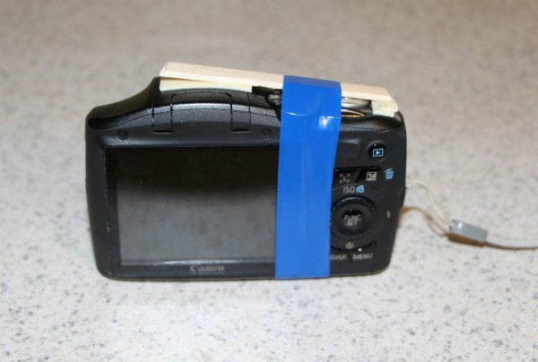
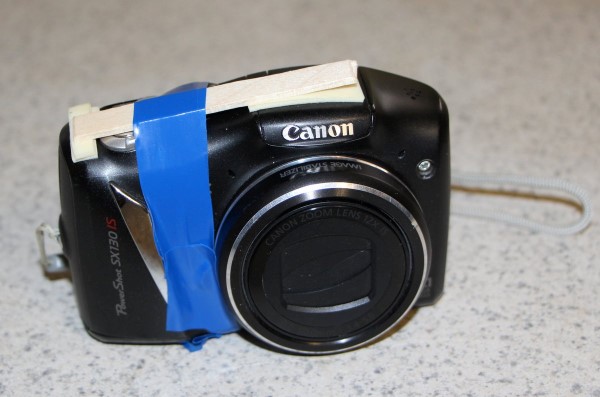
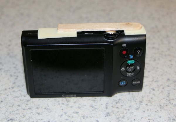
On the last flight we had problems with the Canon cameras shutting down shortly after launch. After some discussions on the GPSL email reflector, I'll be making some slight modifications to the camera payload box to see if we can't eliminate or at least narrow down that problem.
The largest changes for this flight will actually come on the ground. I've made about 40 small fixes, patches, and new features to Balloon Finder since the last flight. New features include RF-to-Internet gating of traffic to help out our smart-phone chasers, support for KISS-type TNC's, a new map tiles downloader feature, many small improvements to the UI, lots of fixes and enhancements to the map viewer component to make it more stable and accurate, and lots of other small items. I'm getting very close to a full public release of the software to the balloooning community.
| Launch Date/Time | Saturday Oct 5, 2013, 8:00am local, 13:00Z | |
| Alternative Date | n/a | |
| Launch Site | Crossroads Christian Church in Hutchinson, KS. (38.1015, -97.9399) | |
| Capsule 1 (Track) |
ArduinoTrack with Radio Shack HTX-200 HT with vertically polarized dipole. Canon A570IS camera running CHDK. W0ZC-11. | .90kg |
| Capsule 2 (Track) |
OpenTrack+ controller with Radio Shack HTX-200 HT with vertically polarized dipole. W0ZC-12. | .90kg |
| Capsule 3 | Camera payload with A2300 and SX130IS. | .55kg |
| Recovery / Misc |
Rocketman Parachute (.20kg) and misc rigging (.15kg). | .35kg |
| Total Flight Weight | Total neck weight on the balloon. | 2.70kg |
| Balloon / Gas | 600g Kaymont with 5.6cu meters Hydrogen. 2.2m diameter. Free lift (5.7kg) | |
| Estimated Burst Altitude | 22,250 MSL (73,000') | |
| Estimated Ascent Rate | 400 m/min (1320'/min) | |
| Estimated Descent Rate | 350 m/min (1150'/min) | |
| Chase Frequencies | 446.000MHz |
Predictions
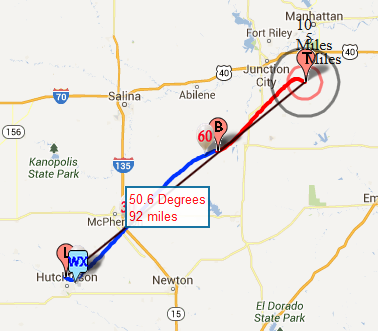
Friday 4 October, 2013. NE Track, landing 19 km southeast of Junction City. Still heading northeast and bouncing around just south of I-70. I'll evaluate the predictions in the morning and make the final call whether to under-inflate, or over-inflate. At this point, either route should ensure a safe landing site.
Thursday 3 October, 2013. NE Track, landing 50 km north-northeast of Emporia. Things shifted a little bit again today. I revised all of the predictions based on more realistic ascent rates and burst altitudes, based on LiftWin. With all of this data, things are shaping up for a long, fast chase, but still safe in terms of highways and city landings. If they continue to extend outward, then we will need to under-fill the balloon and push out over the top, but I have a feeling that this data will work. We'll be looking for about 3kg of positive lift from the balloon to achieve these numbers.
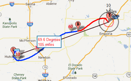
Wednesday 2 October, 2013. NE Track, landing 35 km southwest of Topeka. The forecast has settled in on a northeast track. So far it is staying well away from Topeka and the I-70 and 335 turnpike. At this rate, we will be over-inflating the envelope somewhat to keep the ascent rate up.
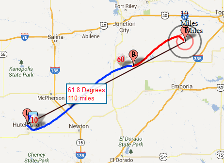
Monday 30 September, 2013. NE Track, landing 24 km north of Emporia. Today's forecast made a major deviation over past tracks. This could indicate that a front is passing through about the time of the launch and actual trajectory may depend on which side of that front we get in on.
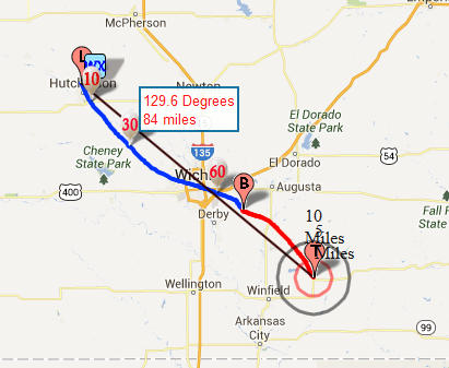
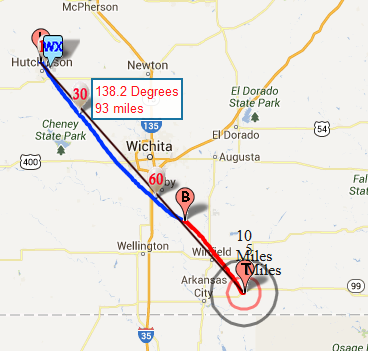
Sunday 29 September, 2013. SE Track, landing 20 km east-northeast of Winfield. This path passes over the top of Wichita, but it will be above most controlled air traffic by the time it approaches the city. I'd prefer to avoid a burst over the city in the outside chance that we had a payload separation at that point, but I'm feeling pretty confident that we can adjust fill rates to avoid that scenario if need be.
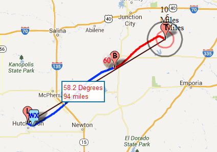
Saturday 28 September, 2013. SE Track, landing 20 km east of Arkansas City, KS. This is the second prediction that I've run and they're showing a pretty consisten SE track. The city of Wichita shouldn't be a factor if the range continues to be so far downwind.
Flight Results
| Launch Date/Time | 5 October 2013, 13:03 UTC |
| Launch Site | Crossroads Christian Church in Hutchinson, KS. (38.1015, -97.9399) |
| Burst Altitude | 24,680m MSL (80,971') |
| Average Ascent Rate | Initially measured around 330m/min (1080'/min), but dropped to around 245m/min (802'/min) after crossing through about 3,000m MSL. Final ascent rates near burst began to climb back up towards 305m/min (1000'/min). |
| Measured Descent Rate | 374m/min (1,224'/min) |
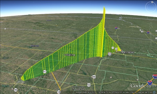
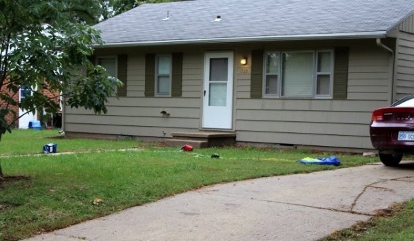
| Touchdown Site | Near K-State campus in downtown Manhattan, KS. (39.196, -96.59) |
| Touchdown Time | 5 October 2013, 15:04 UTC |
| Recovery Time | 5 October 2013, 15:16 UTC |
| Distance Traveled | 169km (105mi) |
| Total Flight Time | 2:01 |
| Downloads | W0ZC-11 Logs W0ZC-12 Logs Google Earth KML |
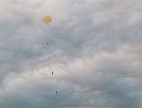
Photo Highlights
Lessons Learned
- The Balloon Finder changes worked well. I identified a few more small issues to be resolved before releasing for public consumption, but overall it's 98% ready.
- The Bluetooth GPS and Bluetooth TNC-X worked flawlessly. I had a small issue with GPS not connecting initially at the start, but once I re-attached it they stayed online.
- Our ascent rate was not consistent throughout the flight. It started off near our intended goal of just over 1000'/min. Shortly after launch the rate dropped steadily to under 800'/min until suddenly recovering minutes before burst. The variation in ascent rate concerned us that the balloon may go neutrally-buoyant, and we wished there had been a cut-down that could be commanded from the ground. Ultimately the ascent rate continued normally to burst. Unfortunately the slow ascent caused us to drift much further north and we wound up landing in the middle of Manhattan, KS, without further incident.
- Preliminary results on the camera changes look promising. Adding a piece of popcicle stick over the top of the shutter button seemed to have fixed the shutdown problem on the Canon SX130IS. The A2300 still is having problems and I have not identified that yet, although it is running a different CHDK script, so I suppose that deserves a look.