The third flight for 2014 is being scheduled to test the Telit GPS module again. During the 2014b flight, the JN3 GPS module proved to be inadequate for high altitude ballooning. After consulting with the Telit support, it was determined that the Telit SL389 v2 module should work, but sourcing that module proved to be difficult.
All of the issues with the new controller on 2014b have been resolved, and the firmware has been updated on the new controller and should be ready for a final production build after this flight if the GPS proves reliable.
Many new enhancements to Balloon Finder have been wrapped into the latest releases. Some of them haven't been released to the public yet, including an exciting new feature where the position of the balloon will be audibly announced at intervals throughout the flight.
I have some new smaller LiPo batteries that if I can find time to test, I would like to fly them on 2014c to shave off another 50g of mass.
{2jtoolbox_content tabs id:3 begin title: Flight Parameters}
| Launch Date/Time | Saturday, October 11th at 7:30am (12:30Z) | |
| Alternative Date | n/a | |
| Launch Site | Crossroads Christian Church in Hutchinson (38.1015N, -97.9399W) | |
| Capsule 1 (Track) |
ArduinoTrack with Radio Shack HTX-200 HT with vertically polarized dipole. Canon A570IS camera running CHDK. GoPro Hero pointed vertically. W0ZC-11. | 0.984kg |
| Capsule 2 (Track) |
ArduinoTrack with RadioMetrix 300mW transmitter and Telit SL869v2 GPS. W0ZC-12 Sparkfun 434MHZ transmitter module, transmitting AM modulated RF on 433.895 +/- 10khz. Beacons the W0ZC callsign every 5 seconds. |
0.594kg |
| Recovery / Misc |
Rocketman Parachute (.20kg) and misc rigging (.15kg). | 0.35kg |
| Total Flight Weight | Total neck weight on the balloon. | 1.928kg |
| Balloon / Gas | 1500g Kaymont with 4.0cu meters (140cu ft) Hydrogen. Neck lift (2.6kg) / Net life (0.6kg) | |
| Estimated Burst Altitude | 34,050m MSL (112,000') | |
| Estimated Ascent Rate | 3.6 m/sec (710'/min) | |
| Estimated Descent Rate | 425 m/min (1400'/min) | |
| Chase Frequencies | 446.000MHz |
{2jtoolbox_content tabs id:3 title: Tracking Predictions}
October 10 - Revised parameters
In order to make sure we hit a critical altitude for the secondary GPS, we're going to switch out the 600g balloon for a 1500g balloon. Since we have otherwise moderate upper-level winds, we're going to push it for a slow acent rate to try to get as much altitude as possible. This alternate prediction is for 112,000' at 710'/min.
October 10
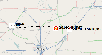
The predictions have pushed out a little bit as I'm playing with some options to extend the flight into the 80,000's. Any landing sceneo that I look at is workable and is in the same general area. If the surface winds are cooperative in the morning, we will probably opt for the same 600g balloon and just under-inflate slightly to get us into the 80's.
October 9
A little bit closer in back to the west, but some general course. I filed the NOTAM tonight for a eastern flight path.
October 7
Same general path as before, but it is slowly shifting north. The surface weather looks chily but favorable. Unless the forecasts change, plan on launching and then hanging out at the church until we hit at least 10,000m before heading out to chase.
October 5
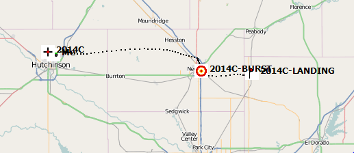
Predictions continue to push the balloon east across Newton, landing between Peabody & El Dorado.
October 1
Today's prediction shifted east instead of south.
September 30
It was the same general track, but a little bit further west.
September 28
Our first prediction after switching up the launch date. Today's prediction is placing the landing about 8 miles north of Winfield on the opposite side of Wichita.
{2jtoolbox_content tabs id:3 title: Flight Results}
| Launch Date/Time | Saturday, October 11th at 8:12am (13:12Z) |
| Launch Site | Crossroads Christian Church in Hutchinson (38.1015N, -97.9399W) |
| Burst Altitude | 33438m MSL (109,708') |
| Average Ascent Rate | 3.38m/s (666'/min) |
| Measured Descent Rate | 8.01m/s (1578'/min) with a badly-fouled parachute. |
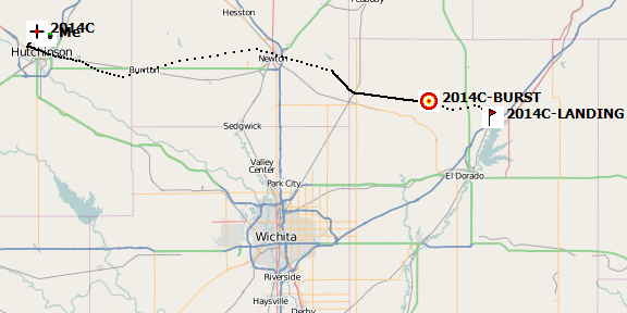
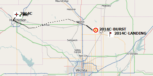
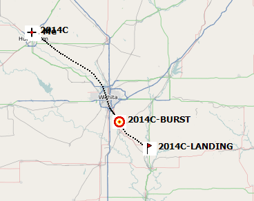
| Touchdown Site | 37.9863N, -96.8880W |
| Touchdown Time | Saturday, October 11th at 11:28am (16:28Z) |
| Recovery Time | Saturday, October 11th at 11:42am (16:42Z) |
| Distance Traveled | 93km (58mi) |
| Total Flight Time | 3 hours, 30 minutes |
| Downloads | W0ZC-11 Log, W0ZC-12 Log, Flight Path (KML), Winds Aloft Forecast |
The weather was beautiful for an early morning October launch. There as almost no wind during filling and release, and even at touchdown, the winds were still very light.
The primary objective of this flight was to test the Telit GPS which performed very well during the flight. Because of the fear of not getting the GPS high enough for a full test, it was decided at the last minute to swap out the 600g balloon for a 1500g balloon, and still proceed with a low fill (600g positive lift). Because of the low winds we were able to nail that fill to within 10% of the estimated ascent rate.
- All of the ArduinoTrack bugs that we encountered on 2014b have been fixed, and the controller worked as designed.
- The Telit GPS module was in fact the correct v2 module as Digikey suggested. It worked just fine all the way up to 33,000m+ altitude.
- The new MicroSD card fixed the issue we had been having the with GoPro camera. During testing it was realized that the camera was capable of recording almost three hours of video non-stop on the stock battery. We left the extra battery pack off off this flight as well as the extra-large enclosure, and saved quite a bit of weight.
{2jtoolbox_content tabs id:3 title: Photo Highlights}
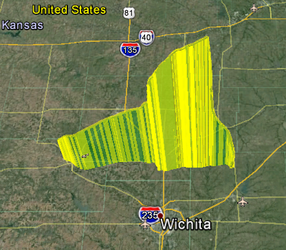
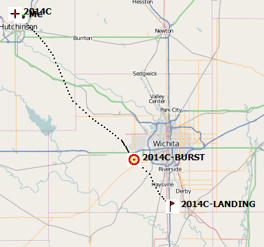
The flight path out of Hutchinson, across Newton, and landing just north of El Dorado, KS.
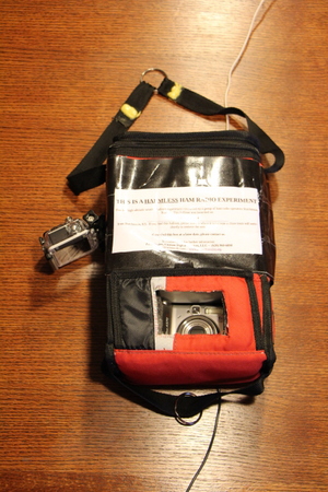
The primary payload, W0ZC-11 with the GoPro pointed up at the balloon and parachute, as well as the Canon A570IS running CHDK.
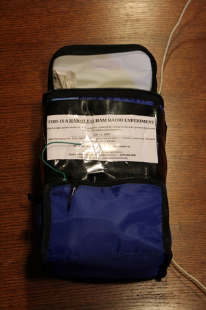
The secondary payload running the new ArduinoTrack controller on W0ZC-12. The green wire hanging out is the 400MHz backup transmitter.
The primary controller that we've flown for a few years now. The transmitter is a Radio Shack HTX-200 that has been modified to break the power and transmit-audio out into a six-pin plug. The GPS is an Inventek GPS module with active helical antenna.
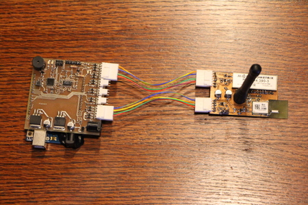
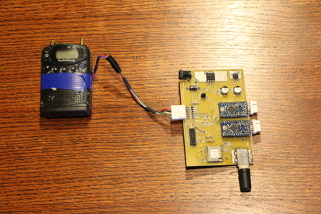
The new ArduinoTrack controller with the prototype Telit GPS module and transmitter module. The Telit GPS has been replaced with a model that we think will survive to HAB altitudes, although there is some questions as to whether this is the right unit or not.
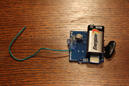
This is the 434MHz backup beacon with its attached 9V battery. The transmitter is a Sparkfun module that just costs a couple of bucks.
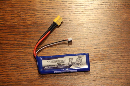
These are the newer Lipo batteries that we'll be flying this time. They shave off 26 grams each with minimal impact on battery life (1800mAh vs. 2200mAh). As we saw last time, be 2200's are good for a launch around 8pm and were still barely charged when we retrieved them the next morning around 8am. We could certainly get by with a much smaller pack for a simple backup beacon.
More photos can be found in the Photo Gallery, Flight 2014c
{2jtoolbox_content tabs id:3 end}